3762/6489
)
)
)
)
)
)
)
)
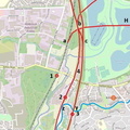
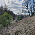
 railway, including the bridge over the stub of the River Irwell that was retained to give access to Boysnope Wharf.")
Not really relevant to the local night soil tramways, but this view looking south-westwards from near the Irlam side of Hulme Bridge Ferry shows the route of the Manchester Ship Canal (MSC) railway, including the bridge over the stub of the River Irwell that was retained to give access to Boysnope Wharf.
- Created on
- Wednesday 24 March 2021
- Posted on
- Saturday 27 March 2021
- Keywords
- Disused Railway, England, United Kingdom
- Albums
- Visits
- 1213
- Rating score
- no rating
- Rate this photo