4/48
)
)
)
)
)
)
)
)
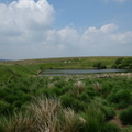
 and Fernilee (right) reservoirs. The access road to Errwood reservoir uses the trackbed of the incline.")
Looking down Bunsall Incline to Errwood (left) and Fernilee (right) reservoirs. The access road to Errwood reservoir uses the trackbed of the incline.
- Created on
- Sunday 10 June 2018
- Posted on
- Thursday 24 October 2019
- Keywords
- 1435 mm Gauge, Cromford & High Peak Railway, Disused Railway, England, Inclined Plane, United Kingdom
- Visits
- 7672
- Rating score
- no rating
- Rate this photo