17/36
)
)
)
)
)
)
)
)
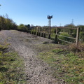
 just south of Killamarsh South Junction (point c on map). Just beyond, the MS&LR/GCR overbridge (line B on map) can be seen.")
This footpath, heading westwards from the south end of Rother Valley Lake, passes under the LD&ECR/GCR route (line C on map) just south of Killamarsh South Junction (point c on map). Just beyond, the MS&LR/GCR overbridge (line B on map) can be seen.
- Created on
- Monday 5 April 2021
- Posted on
- Monday 5 April 2021
- Keywords
- Disused Railway, England, United Kingdom
- Visits
- 1674
- Rating score
- no rating
- Rate this photo