)
)
)
)
)
)
)
)
 middle left then runs left to right across the middle of the picture, the formation and earthworks can be seen even though the line closed in 1892. At this point the line was at 382 m (1254 ft) above sea level.")
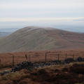
Looking across the valley towards the Buxton - Whaley Bridge road, Errwood Reservoir is down below out of view. Inevitably there is railway interest in this view - the Cromford and High Peak Railway climbs up the Bunsall incline (1 in 7/7.5) middle left then runs left to right across the middle of the picture, the formation and earthworks can be seen even though the line closed in 1892. At this point the line was at 382 m (1254 ft) above sea level.
- Created on
- Tuesday 4 December 2018
- Posted on
- Sunday 3 November 2019
- Visits
- 4542
- Rating score
- no rating
- Rate this photo